Geolocate

Obernesselbach topographic map

Click on the map to display elevation.

Obernesselbach

Im Geographischen statistisch-topographischen Lexikon von Franken (1801) wird der Ort folgendermaßen beschrieben.

Wikipedia (CC-BY-SA 3.0)

About this map

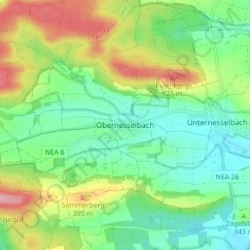
Name: Obernesselbach topographic map, elevation, terrain.

Location: Obernesselbach, Neustadt an der Aisch, Landkreis Neustadt an der Aisch-Bad Windsheim, Bayern, 91474, Deutschland (49.56134 10.46752 49.60134 10.50752)

Average elevation: 347 m

Minimum elevation: 301 m

Maximum elevation: 431 m

Other topographic maps

Click on a map to view its topography, its elevation and its terrain.

Gear up for your next adventure:

🥾Hiking Gaiters - Protect legs and shoes from mud, snow, and debris
🎒Hiking Backpack - Lightweight and ergonomic backpacks for day hikes or multi-day treks
🚲Handlebar Phone Mount - View topographic-map.com live while cycling
🧭GPS Outdoor Watch - Smart watch for navigation and fitness tracking in nature
🛰️Satellite Messenger - Emergency communication for areas with no cell service

As an Amazon Associate, this site earns from qualifying purchases at no extra cost to you.