Geolocate

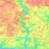
Lannevain topographic map

Click on the map to display elevation.

About this map

Name: Lannevain topographic map, elevation, terrain.

Location: Lannevain, Clohars-Carnoët, Quimper, Finistère, Bretagne, France métropolitaine, 29360, France (47.77305 -3.60064 47.81305 -3.56064)

Average elevation: 47 m

Minimum elevation: 0 m

Maximum elevation: 68 m

Other topographic maps

Click on a map to view its topography, its elevation and its terrain.
La Laïta

France > Bretagne > Finistère > Clohars-Carnoët

Average elevation: 45 m

Gear up for your next adventure:

🕶️Polarized Sunglasses - Reduces glare from snow and water at high elevations
🧴First Aid Kit - Essential first aid supplies for outdoor emergencies
🥾Waterproof Hiking Shoes - Durable shoes for wet and rugged trails
⛺Family Camping Tent - Spacious tent suitable for family camping trips
🧥Insulated Jacket - Keep warm in cold outdoor conditions

As an Amazon Associate, this site earns from qualifying purchases at no extra cost to you.