Geolocate

Derby topographic map

Click on the map to display elevation.

About this map

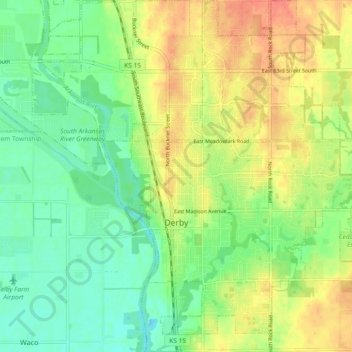
Name: Derby topographic map, elevation, terrain.

Location: Derby, Sedgwick County, Kansas, United States (37.51865 -97.28138 37.59173 -97.20811)

Average elevation: 393 m

Minimum elevation: 372 m

Maximum elevation: 418 m

Other topographic maps

Click on a map to view its topography, its elevation and its terrain.

Murray Gill

United States > Kansas > Sedgwick County

Average elevation: 395 m

Furley

United States > Kansas > Sedgwick County

Average elevation: 426 m

Sand Burr Hill

United States > Kansas > Sedgwick County > Wichita

Average elevation: 385 m

Wichita

United States > Kansas > Sedgwick County > Wichita

Average elevation: 410 m

Gear up for your next adventure:

🦶Anti-Blister Balm - Prevents friction and hotspots during long ascents
🏕️Camping Hammock - Integrated protection for sleeping between trees
🧴Bear Spray Holster - Quick-access carry for essential Canadian wilderness safety
🧥Insulated Jacket - Keep warm in cold outdoor conditions
🧊Portable Cooler - Keep food and drinks cold during outdoor adventures

As an Amazon Associate, this site earns from qualifying purchases at no extra cost to you.