
Make a donation
Gear up for your next adventure:
As an Amazon Associate, this site earns from qualifying purchases at no extra cost to you.
South Brooksville topographic map
Click on the map to display elevation.
Make a donation
Gear up for your next adventure:
As an Amazon Associate, this site earns from qualifying purchases at no extra cost to you.
About this map
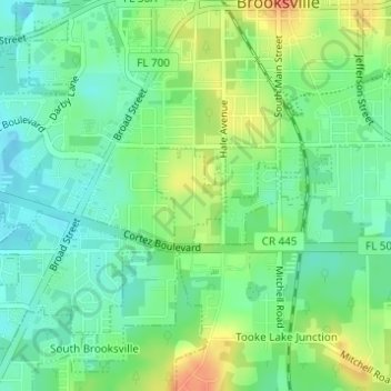
Name: South Brooksville topographic map, elevation, terrain.
Location: South Brooksville, Hernando County, Florida, United States (28.53841 -82.39756 28.54534 -82.38797)
Average elevation: 41 m
Minimum elevation: 23 m
Maximum elevation: 70 m
Make a donation
Gear up for your next adventure:
As an Amazon Associate, this site earns from qualifying purchases at no extra cost to you.
Other topographic maps
Click on a map to view its topography, its elevation and its terrain.
Weeki Wachee Spring
United States > Florida > Hernando County > Spring Hill > Weeki Wachee
Average elevation: 11 m
Weeki Wachee Acres
United States > Florida > Hernando County > Weeki Wachee Acres
Average elevation: 11 m
Make a donation
Gear up for your next adventure:
As an Amazon Associate, this site earns from qualifying purchases at no extra cost to you.