
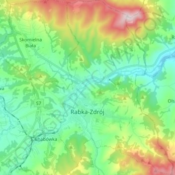
Rabka-Zdrój topographic map
Interactive map
Click on the map to display elevation.
About this map
Name: Rabka-Zdrój topographic map, elevation, terrain.
Average elevation: 594 m
Minimum elevation: 422 m
Maximum elevation: 1,007 m
Other topographic maps
Click on a map to view its topography, its elevation and its terrain.
Ochotnica Dolna
Poland > Lesser Poland Voivodeship > Nowy Targ County
Ochotnica Dolna, gmina Ochotnica Dolna, Nowy Targ County, Lesser Poland Voivodeship, 34-452, Poland
Average elevation: 715 m
Gronków
Poland > Lesser Poland Voivodeship > Nowy Targ County
Gronków, gmina Nowy Targ, Nowy Targ County, Lesser Poland Voivodeship, Poland
Average elevation: 628 m
Nowy Targ
Poland > Lesser Poland Voivodeship > Nowy Targ County > Nowy Targ
Nowy Targ, Nowy Targ County, Lesser Poland Voivodeship, Poland
Average elevation: 676 m