
Thank you for supporting this site ❤️
Make a donation
Make a donation
Gear up for your next adventure:
As an Amazon Associate, this site earns from qualifying purchases at no extra cost to you.
Os Bosteiros - Ceidón topographic map
Click on the map to display elevation.
Thank you for supporting this site ❤️
Make a donation
Make a donation
Gear up for your next adventure:
As an Amazon Associate, this site earns from qualifying purchases at no extra cost to you.
About this map
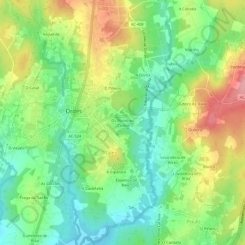
Name: Os Bosteiros - Ceidón topographic map, elevation, terrain.
Location: Os Bosteiros - Ceidón, Ordes, Corunha, Galiza, 15680, Espanha (43.05480 -8.41689 43.09480 -8.37689)
Average elevation: 294 m
Minimum elevation: 244 m
Maximum elevation: 368 m
Thank you for supporting this site ❤️
Make a donation
Make a donation
Gear up for your next adventure:
As an Amazon Associate, this site earns from qualifying purchases at no extra cost to you.