Geolocate

Varatojo topographic map

Click on the map to display elevation.

About this map

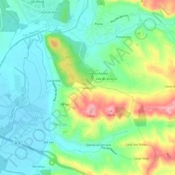
Name: Varatojo topographic map, elevation, terrain.

Location: Varatojo, Maiorga, Alcobaça, Leiria, 2460-453, Portugal (39.56733 -8.99192 39.60733 -8.95192)

Average elevation: 51 m

Minimum elevation: 5 m

Maximum elevation: 149 m

Gear up for your next adventure:

🎒Backpack Rain Cover - External shield to keep your entire pack dry
🧢Outdoor Cap - Protective cap for sun and rain during hikes
🥾Trail Running Boots - Durable shoes designed for trail running
🛶Waterproof Dry Bags - Keep electronics and clothes dry during river crossings
🔦LED Headtorch - Bright and durable light for night activities

As an Amazon Associate, this site earns from qualifying purchases at no extra cost to you.