Geolocate

Burney topographic map

Click on the map to display elevation.

About this map
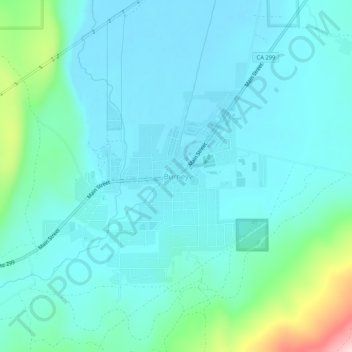
Name: Burney topographic map, elevation, terrain.

Location: Burney, Shasta County, California, 96013, United States (40.86238 -121.68082 40.90238 -121.64082)

Average elevation: 989 m

Minimum elevation: 943 m

Maximum elevation: 1,221 m

Other topographic maps

Click on a map to view its topography, its elevation and its terrain.
Shasta Lake

United States > California > Shasta County

Average elevation: 281 m

Lake Britton

United States > California > Shasta County

Average elevation: 939 m

Palo Cedro

United States > California > Shasta County > Palo Cedro

Palo Cedro is located at 40°33′4″N 122°14′3″W / 40.55111°N 122.23417°W / 40.55111; -122.23417 (40.551091, −122.234255) at an elevation of 465 ft (143 m) above sea level.

Average elevation: 157 m

Anderson

United States > California > Shasta County

Average elevation: 151 m

Cottonwood

United States > California > Shasta County

Average elevation: 140 m

Shingletown

United States > California > Shasta County

Average elevation: 920 m

Turquoise Pool

United States > California > Shasta County

Average elevation: 2,406 m

Gear up for your next adventure:

🔭Outdoor Binoculars - Lightweight binoculars for birdwatching and hiking
🥾Waterproof Hiking Shoes - Durable shoes for wet and rugged trails
🥾Trail Running Boots - Durable shoes designed for trail running
🧤Insulated Winter Gloves - Heavy-duty protection for sub-zero Canadian adventures
🔭Compact Monocular - One-handed bird watching and trail spotting

As an Amazon Associate, this site earns from qualifying purchases at no extra cost to you.