
Make a donation
Gear up for your next adventure:
As an Amazon Associate, this site earns from qualifying purchases at no extra cost to you.
Huasao topographic map
Click on the map to display elevation.
Make a donation
Gear up for your next adventure:
As an Amazon Associate, this site earns from qualifying purchases at no extra cost to you.
About this map
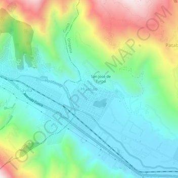
Name: Huasao topographic map, elevation, terrain.
Location: Huasao, Oropesa, Quispicanchi, Cusco, Perú (-13.58997 -71.83247 -13.54997 -71.79247)
Average elevation: 3,344 m
Minimum elevation: 3,102 m
Maximum elevation: 3,906 m
Make a donation
Gear up for your next adventure:
As an Amazon Associate, this site earns from qualifying purchases at no extra cost to you.
Other topographic maps
Click on a map to view its topography, its elevation and its terrain.
Parque Arqueológico Nacional de Tipón
Perú > Cusco > Oropesa > Choccepata / Pitupuggio
Ubicado a una altitud de 3.560 m.s.n.m. Tipón fue un gran santuario donde el agua era adorada con el cuidado y veneración que los incas trataban a este elemento.
Average elevation: 3,472 m