
Make a donation
Gear up for your next adventure:
As an Amazon Associate, this site earns from qualifying purchases at no extra cost to you.
West Boylston topographic map
Click on the map to display elevation.
Make a donation
Gear up for your next adventure:
As an Amazon Associate, this site earns from qualifying purchases at no extra cost to you.
About this map
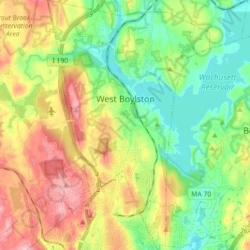
Name: West Boylston topographic map, elevation, terrain.
Average elevation: 174 m
Minimum elevation: 111 m
Maximum elevation: 269 m
Make a donation
Gear up for your next adventure:
As an Amazon Associate, this site earns from qualifying purchases at no extra cost to you.
Other topographic maps
Click on a map to view its topography, its elevation and its terrain.
Make a donation
Gear up for your next adventure:
As an Amazon Associate, this site earns from qualifying purchases at no extra cost to you.
Make a donation
Gear up for your next adventure:
As an Amazon Associate, this site earns from qualifying purchases at no extra cost to you.
Make a donation
Gear up for your next adventure:
As an Amazon Associate, this site earns from qualifying purchases at no extra cost to you.
Make a donation
Gear up for your next adventure:
As an Amazon Associate, this site earns from qualifying purchases at no extra cost to you.
Tufts
United States > Massachusetts > Worcester County > Harvard > Camp Green Eyrie
Average elevation: 117 m
Make a donation
Gear up for your next adventure:
As an Amazon Associate, this site earns from qualifying purchases at no extra cost to you.
Make a donation
Gear up for your next adventure:
As an Amazon Associate, this site earns from qualifying purchases at no extra cost to you.
Windmere Drive
United States > Massachusetts > Worcester County > Southborough
Average elevation: 95 m
South Ashburnham
United States > Massachusetts > Worcester County > Ashburnham
Average elevation: 322 m
Make a donation
Gear up for your next adventure:
As an Amazon Associate, this site earns from qualifying purchases at no extra cost to you.
Teneriffe Hill
United States > Massachusetts > Worcester County > East Brookfield
Average elevation: 201 m
Make a donation
Gear up for your next adventure:
As an Amazon Associate, this site earns from qualifying purchases at no extra cost to you.
Shrewsbury Street
United States > Massachusetts > Worcester County > Worcester
Average elevation: 164 m
Make a donation
Gear up for your next adventure:
As an Amazon Associate, this site earns from qualifying purchases at no extra cost to you.
Beverly Road
United States > Massachusetts > Worcester County > Worcester > Beverly Road
Average elevation: 174 m
Bullardville
United States > Massachusetts > Worcester County > Winchendon > Bullardville
Average elevation: 290 m
Hovey Dam
United States > Massachusetts > Worcester County > Grafton > North Grafton
Average elevation: 116 m
North Rutland
United States > Massachusetts > Worcester County > Rutland > North Rutland
Average elevation: 287 m
Make a donation
Gear up for your next adventure:
As an Amazon Associate, this site earns from qualifying purchases at no extra cost to you.
East Village
United States > Massachusetts > Worcester County > Webster > East Village
Average elevation: 159 m
Farnumsville
United States > Massachusetts > Worcester County > Grafton > Farnumsville
Average elevation: 127 m
Make a donation
Gear up for your next adventure:
As an Amazon Associate, this site earns from qualifying purchases at no extra cost to you.
Make a donation
Gear up for your next adventure:
As an Amazon Associate, this site earns from qualifying purchases at no extra cost to you.
Marks Garrison
United States > Massachusetts > Worcester County > West Brookfield
Average elevation: 205 m