
Make a donation
Gear up for your next adventure:
As an Amazon Associate, this site earns from qualifying purchases at no extra cost to you.
Combrailles topographic map
Click on the map to display elevation.
Make a donation
Gear up for your next adventure:
As an Amazon Associate, this site earns from qualifying purchases at no extra cost to you.
About this map
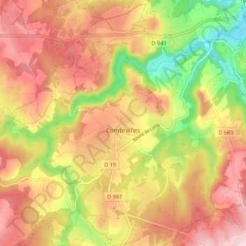
Name: Combrailles topographic map, elevation, terrain.
Average elevation: 667 m
Minimum elevation: 534 m
Maximum elevation: 766 m
Make a donation
Gear up for your next adventure:
As an Amazon Associate, this site earns from qualifying purchases at no extra cost to you.
Other topographic maps
Click on a map to view its topography, its elevation and its terrain.
Rouade
Frankrijk > Auvergne-Rhône-Alpes > Puy-de-Dôme > Saint-Amant-Roche-Savine
Average elevation: 888 m
Réserve naturelle du rocher de la Jacquette
Frankrijk > Auvergne-Rhône-Alpes > Puy-de-Dôme > Mazoires > Saulzet
Average elevation: 1,058 m
Make a donation
Gear up for your next adventure:
As an Amazon Associate, this site earns from qualifying purchases at no extra cost to you.
La Croix Saint-Martin
Frankrijk > Auvergne-Rhône-Alpes > Puy-de-Dôme > Arconsat
Average elevation: 829 m
L'Ebaupin
Frankrijk > Auvergne-Rhône-Alpes > Puy-de-Dôme > Saint-Priest-des-Champs
Average elevation: 649 m
Make a donation
Gear up for your next adventure:
As an Amazon Associate, this site earns from qualifying purchases at no extra cost to you.
Make a donation
Gear up for your next adventure:
As an Amazon Associate, this site earns from qualifying purchases at no extra cost to you.
Vassivière
Frankrijk > Auvergne-Rhône-Alpes > Puy-de-Dôme > Besse-et-Saint-Anastaise
Average elevation: 1,283 m
Make a donation
Gear up for your next adventure:
As an Amazon Associate, this site earns from qualifying purchases at no extra cost to you.
La Terasse
Frankrijk > Auvergne-Rhône-Alpes > Puy-de-Dôme > Saint-Dier-d'Auvergne
Average elevation: 506 m
Saint-Nectaire le Bas
Frankrijk > Auvergne-Rhône-Alpes > Puy-de-Dôme > Saint-Nectaire
Average elevation: 768 m
Make a donation
Gear up for your next adventure:
As an Amazon Associate, this site earns from qualifying purchases at no extra cost to you.