Geolocate

Paris topographic map

Click on the map to display elevation.

About this map

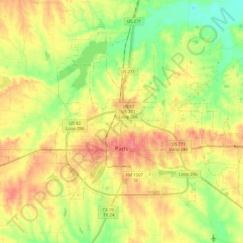
Name: Paris topographic map, elevation, terrain.

Location: Paris, Lamar County, Texas, United States (33.62063 -95.62794 33.73839 -95.43541)

Average elevation: 159 m

Minimum elevation: 125 m

Maximum elevation: 192 m

Gear up for your next adventure:

🥾Trail Running Shoes - Lightweight and durable shoes for trail running
🧥Insulated Jacket - Keep warm in cold outdoor conditions
🧥Softshell Jacket - Windproof and breathable jacket for hiking
🥾Hiking Gaiters - Protect legs and shoes from mud, snow, and debris
🪑Ultralight Camping Stool - Compact seating for rest stops during long hikes

As an Amazon Associate, this site earns from qualifying purchases at no extra cost to you.