Geolocate

Canal Fulton topographic map

Click on the map to display elevation.

About this map

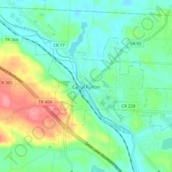
Name: Canal Fulton topographic map, elevation, terrain.

Location: Canal Fulton, Stark County, Ohio, 44614, United States (40.87545 -81.61782 40.90459 -81.54928)

Average elevation: 308 m

Minimum elevation: 283 m

Maximum elevation: 369 m

Other topographic maps

Click on a map to view its topography, its elevation and its terrain.

Myers

United States > Ohio > Stark County

Average elevation: 348 m

New England

United States > Ohio > Stark County > Massillon

Average elevation: 318 m

Mount Vernon

United States > Ohio > Stark County > Canton

Average elevation: 344 m

Lake Cable

United States > Ohio > Stark County

Average elevation: 340 m

Mount Union

United States > Ohio > Stark County > Alliance > Mount Union

Average elevation: 363 m

Maple Leaf Lake

United States > Ohio > Stark County

Average elevation: 354 m

Gear up for your next adventure:

👖Convertible Hiking Pants - Zip-off legs to adapt to changing weather conditions
🧢Sun Hat - Wide-brim hat for sun protection
🥽Outdoor Goggles - Protective eyewear for outdoor activities
💡LED Headlamp - Hands-free illumination for night hiking and camping
Camping Groundsheet - Protect your tent from moisture and dirt

As an Amazon Associate, this site earns from qualifying purchases at no extra cost to you.