
Make a donation
Gear up for your next adventure:
As an Amazon Associate, this site earns from qualifying purchases at no extra cost to you.
Spahl topographic map
Click on the map to display elevation.
Make a donation
Gear up for your next adventure:
As an Amazon Associate, this site earns from qualifying purchases at no extra cost to you.
Spahl
Die geographische Höhe des Ortes beträgt 384 m ü. NN. Höchste Erhebungen in der Spahler Flur sind der Rößberg (639,7 m ü. NN), der Pietzelstein (620,7 m ü. NN), der Suchenberg (583,4 m ü. NN), der Struthkopf (496,5 m ü. NN) und der Spahlerberg (423,4 m ü. NN).
Make a donation
Gear up for your next adventure:
As an Amazon Associate, this site earns from qualifying purchases at no extra cost to you.
About this map
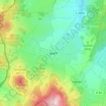
Name: Spahl topographic map, elevation, terrain.
Location: Spahl, Geisa, Wartburgkreis, Thüringen, Deutschland (50.63831 9.89186 50.67831 9.93186)
Average elevation: 431 m
Minimum elevation: 333 m
Maximum elevation: 633 m
Make a donation
Gear up for your next adventure:
As an Amazon Associate, this site earns from qualifying purchases at no extra cost to you.