
Make a donation
Gear up for your next adventure:
As an Amazon Associate, this site earns from qualifying purchases at no extra cost to you.
Sandness topographic map
Click on the map to display elevation.
Make a donation
Gear up for your next adventure:
As an Amazon Associate, this site earns from qualifying purchases at no extra cost to you.
About this map
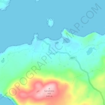
Name: Sandness topographic map, elevation, terrain.
Location: Sandness, Shetland, Scotland, ZE2 9PL, United Kingdom (60.27885 -1.67220 60.31885 -1.63220)
Average elevation: 48 m
Minimum elevation: -3 m
Maximum elevation: 247 m
Make a donation
Gear up for your next adventure:
As an Amazon Associate, this site earns from qualifying purchases at no extra cost to you.
Other topographic maps
Click on a map to view its topography, its elevation and its terrain.
Out Skerries
United Kingdom > Scotland > Shetland
Being so close to Norway, the islands were of strategic importance in World War II and were a regular landfall for Norwegian boats carrying escapees from the Nazi occupation. The local coastguard were responsible for the refugees and at one point during the war were issued with a tommy gun, although initially…
Average elevation: 1 m
Lerwick
United Kingdom > Scotland > Shetland
Lerwick has transitioned from a subpolar oceanic climate (Cfc) to a maritime climate (Cfb) with cool to cold temperatures all year long. The lack of trees reflects the latter type. This is particularly pronounced by virtue of Lerwick being on the coast of an island, so even extreme temperature records are…
Average elevation: 34 m
Make a donation
Gear up for your next adventure:
As an Amazon Associate, this site earns from qualifying purchases at no extra cost to you.