
Make a donation
Gear up for your next adventure:
As an Amazon Associate, this site earns from qualifying purchases at no extra cost to you.
Woolsey topographic map
Click on the map to display elevation.
Make a donation
Gear up for your next adventure:
As an Amazon Associate, this site earns from qualifying purchases at no extra cost to you.
About this map
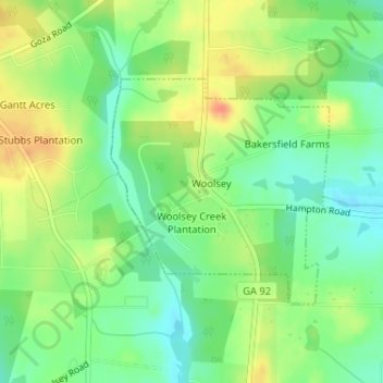
Name: Woolsey topographic map, elevation, terrain.
Location: Woolsey, Fayette County, Georgia, United States (33.35377 -84.42065 33.36971 -84.40222)
Average elevation: 252 m
Minimum elevation: 232 m
Maximum elevation: 277 m
Make a donation
Gear up for your next adventure:
As an Amazon Associate, this site earns from qualifying purchases at no extra cost to you.
Other topographic maps
Click on a map to view its topography, its elevation and its terrain.
Make a donation
Gear up for your next adventure:
As an Amazon Associate, this site earns from qualifying purchases at no extra cost to you.
Burnham Woods
United States > Georgia > Fayette County > Peachtree City > Burnham Woods
Average elevation: 255 m