Geolocate

Falmouth topographic map

Click on the map to display elevation.

About this map

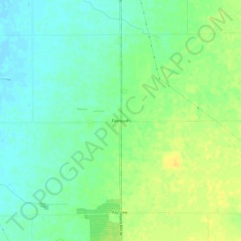
Name: Falmouth topographic map, elevation, terrain.

Location: Falmouth, Rush County, Indiana, United States (39.68094 -85.32109 39.72094 -85.28109)

Average elevation: 319 m

Minimum elevation: 308 m

Maximum elevation: 332 m

Other topographic maps

Click on a map to view its topography, its elevation and its terrain.

Glenwood

United States > Indiana > Rush County

Average elevation: 332 m

Gear up for your next adventure:

🧦Outdoor Socks - Durable socks designed for hiking and outdoor sports
🥾Trekking Boots - Durable boots for long-distance trekking
🧥Waterproof Pants - Keep dry during rainy hiking conditions
💧Filtered Water Bottle - Safe drinking water on the go
Lightweight Backpacking Tent - Compact tent for efficient hiking trips

As an Amazon Associate, this site earns from qualifying purchases at no extra cost to you.