
Portraine topographic map
Interactive map
Click on the map to display elevation.
About this map
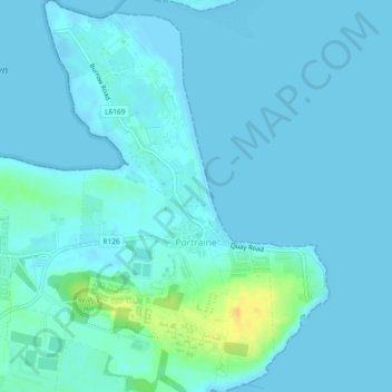
Name: Portraine topographic map, elevation, terrain.
Location: Portraine, Fingal, County Dublin, Leinster, K36 W584, Irlande (53.48288 -6.13020 53.51044 -6.09622)
Average elevation: 4 m
Minimum elevation: -1 m
Maximum elevation: 28 m
Other topographic maps
Click on a map to view its topography, its elevation and its terrain.
Dublin Fingal West
Dublin Fingal West, County Dublin, Leinster, Irlande
Average elevation: 43 m
Portrane
Irlande > County Dublin > Portrane
Portrane, Fingal, County Dublin, Leinster, K36 V064, Irlande
Average elevation: 3 m
Dún Laoghaire
Dún Laoghaire, Dún Laoghaire-Rathdown, County Dublin, Leinster, A96 T860, Irlande
Average elevation: 21 m