
Thank you for supporting this site ❤️
Make a donation
Make a donation
Gear up for your next adventure:
As an Amazon Associate, this site earns from qualifying purchases at no extra cost to you.
龙拉 topographic map
Click on the map to display elevation.
Thank you for supporting this site ❤️
Make a donation
Make a donation
Gear up for your next adventure:
As an Amazon Associate, this site earns from qualifying purchases at no extra cost to you.
About this map
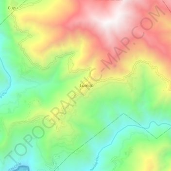
Name: 龙拉 topographic map, elevation, terrain.
Location: 龙拉, Lumla Circle, 达旺, 阿鲁纳恰尔邦 / 阿魯納查邦, 790106, 印度 (27.50345 91.68771 27.58345 91.76771)
Average elevation: 2,166 m
Minimum elevation: 1,061 m
Maximum elevation: 3,740 m
Thank you for supporting this site ❤️
Make a donation
Make a donation
Gear up for your next adventure:
As an Amazon Associate, this site earns from qualifying purchases at no extra cost to you.