Geolocate

Selsborg topographic map

Click on the map to display elevation.

About this map

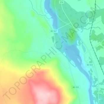
Name: Selsborg topographic map, elevation, terrain.

Location: Selsborg, Piteå kommun, Norrbotten County, 942 94, Sweden (65.47283 21.15732 65.51283 21.19732)

Average elevation: 58 m

Minimum elevation: -5 m

Maximum elevation: 191 m

Other topographic maps

Click on a map to view its topography, its elevation and its terrain.

Kalix kommun

Sweden > Norrbotten County

Average elevation: 33 m

Överkalix kommun

Sweden > Norrbotten County

Average elevation: 165 m

Luleå kommun

Sweden > Norrbotten County

Average elevation: 63 m

Gear up for your next adventure:

🔦LED Headtorch - Bright and durable light for night activities
🌡️Emergency Mylar Blankets - Compact thermal protection for unexpected nights outdoors
🦌Outdoor Trail Camera - Monitor wildlife activity near your favorite spots
🧤Rechargeable Heated Gloves - Extreme warmth for Canadian winter expeditions
🥾Trekking Boots - Durable boots for long-distance trekking

As an Amazon Associate, this site earns from qualifying purchases at no extra cost to you.