
Make a donation
Gear up for your next adventure:
As an Amazon Associate, this site earns from qualifying purchases at no extra cost to you.
Patagonia topographic map
Click on the map to display elevation.
Make a donation
Gear up for your next adventure:
As an Amazon Associate, this site earns from qualifying purchases at no extra cost to you.
Patagonia
Across much of Patagonia east of the Andes, volcanic eruptions have created formation of basaltic lava plateaus during the Cenozoic. The plateaus are of different ages with the older –of Neogene and Paleogene age– being located at higher elevations than Pleistocene and Holocene lava plateaus and outcrops.
Make a donation
Gear up for your next adventure:
As an Amazon Associate, this site earns from qualifying purchases at no extra cost to you.
About this map
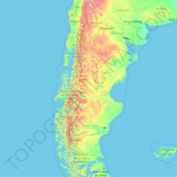
Name: Patagonia topographic map, elevation, terrain.
Location: Patagonia, Argentina (-53.92779 -75.72252 -36.05233 -62.78956)
Average elevation: 173 m
Minimum elevation: -29 m
Maximum elevation: 4,199 m
Make a donation
Gear up for your next adventure:
As an Amazon Associate, this site earns from qualifying purchases at no extra cost to you.
Other topographic maps
Click on a map to view its topography, its elevation and its terrain.