
Make a donation
Gear up for your next adventure:
As an Amazon Associate, this site earns from qualifying purchases at no extra cost to you.
Las Torres de Cotillas topographic map
Click on the map to display elevation.
Make a donation
Gear up for your next adventure:
As an Amazon Associate, this site earns from qualifying purchases at no extra cost to you.
Las Torres de Cotillas
Las Torres de Cotillas es un municipio español de la Región de Murcia, situado en la comarca de la Vega Media del Segura. Cuenta con 21 471 habitantes (INE 2019), tiene una superficie de 39 kilómetros cuadrados y está situada a una altitud de 82 msnm. Forma parte del Área Metropolitana de Murcia, estando situada a 15 kilómetros de la ciudad de Murcia.
Make a donation
Gear up for your next adventure:
As an Amazon Associate, this site earns from qualifying purchases at no extra cost to you.
About this map
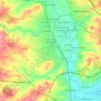
Name: Las Torres de Cotillas topographic map, elevation, terrain.
Average elevation: 110 m
Minimum elevation: 47 m
Maximum elevation: 199 m
Make a donation
Gear up for your next adventure:
As an Amazon Associate, this site earns from qualifying purchases at no extra cost to you.
Other topographic maps
Click on a map to view its topography, its elevation and its terrain.
Molina de Segura
España > Región de Murcia > Vega Media del Segura > Molina de Segura
Average elevation: 118 m
Cotillas
España > Región de Murcia > Vega Media del Segura > Las Torres de Cotillas > San Pedro
Average elevation: 79 m
Make a donation
Gear up for your next adventure:
As an Amazon Associate, this site earns from qualifying purchases at no extra cost to you.
Parque Valencia
España > Región de Murcia > Vega Media del Segura > Las Torres de Cotillas
Average elevation: 97 m
Los Vientos
España > Región de Murcia > Vega Media del Segura > Molina de Segura
Average elevation: 119 m