Geolocate

Dora topographic map

Click on the map to display elevation.

About this map

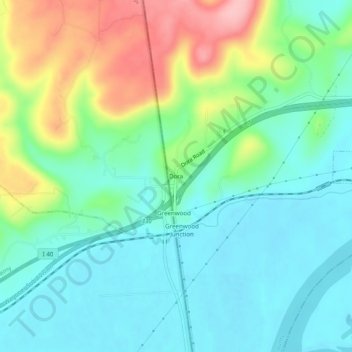
Name: Dora topographic map, elevation, terrain.

Location: Dora, Crawford County, Arkansas, 74946, United States (35.43426 -94.46077 35.47426 -94.42077)

Average elevation: 162 m

Minimum elevation: 118 m

Maximum elevation: 265 m

Other topographic maps

Click on a map to view its topography, its elevation and its terrain.

Van Buren

United States > Arkansas > Crawford County

Average elevation: 147 m

Rudy

United States > Arkansas > Crawford County

Average elevation: 196 m

Chester

United States > Arkansas > Crawford County

Average elevation: 313 m

Kibler

United States > Arkansas > Crawford County

Average elevation: 134 m

Cedarville

United States > Arkansas > Crawford County

Average elevation: 279 m

Alma

United States > Arkansas > Crawford County

Average elevation: 169 m

Mulberry

United States > Arkansas > Crawford County

Average elevation: 133 m

Dyer

United States > Arkansas > Crawford County

Average elevation: 140 m

Gear up for your next adventure:

🔋Solar Power Bank - Keep your GPS and devices charged during long outdoor trips
🧥Softshell Jacket - Windproof and breathable jacket for hiking
🧴Bear Spray Holster - Quick-access carry for essential Canadian wilderness safety
👟Sport Hiking Sandals - Breathable footwear for water crossings and camp rest
🔭Compact Binoculars - Lightweight optics for scouting trails and wildlife

As an Amazon Associate, this site earns from qualifying purchases at no extra cost to you.