Geolocate

Mudh topographic map

Click on the map to display elevation.

About this map

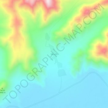
Name: Mudh topographic map, elevation, terrain.

Location: Mudh, Leh Tehsil, Leh District, Ladakh, 194404, India (33.18155 78.67500 33.22155 78.71500)

Average elevation: 4,324 m

Minimum elevation: 4,141 m

Maximum elevation: 4,798 m

Other topographic maps

Click on a map to view its topography, its elevation and its terrain.

Gear up for your next adventure:

🧢Sun Hat - Wide-brim hat for sun protection
🧣Merino Neck Gaiter - Protects against wind, sun, and cold at high altitudes
🧭GPS Handheld Device - Reliable GPS navigation for outdoor adventures
🧼Biodegradable Camp Soap - Environmentally friendly cleaning for gear and body
🧦Outdoor Socks - Durable socks designed for hiking and outdoor sports

As an Amazon Associate, this site earns from qualifying purchases at no extra cost to you.