Geolocate
👉 Easily get elevation data in JSON, GeoTIFF and KML formats using Elevation API
Thank you for supporting this site ❤️
Make a donation

Parque Amarilis topographic map

Click on the map to display elevation.

About this map

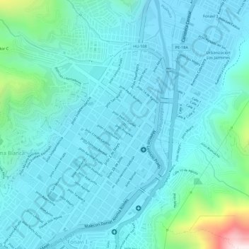
Name: Parque Amarilis topographic map, elevation, terrain.

Location: Parque Amarilis, Huánuco, Loma Blanca, Huánuco, Perú (-9.92588 -76.23888 -9.92462 -76.23758)

Average elevation: 1,960 m

Minimum elevation: 1,871 m

Maximum elevation: 2,459 m

Other topographic maps

Click on a map to view its topography, its elevation and its terrain.

Canchan

Perú > Huánuco > Huánuco

Average elevation: 2,320 m

Pilcomozo

Perú > Huánuco > Huánuco > Marabamba

Average elevation: 2,148 m

Gaganani

Perú > Huánuco > Huánuco

Average elevation: 2,315 m

Marabamba

Perú > Huánuco > Huánuco

Average elevation: 2,141 m

Pucuchinche

Perú > Huánuco > Huánuco

Average elevation: 2,301 m

Marabamba

Perú > Huánuco > Huánuco

Average elevation: 2,141 m

Gaganani

Perú > Huánuco > Huánuco

Average elevation: 2,315 m

Gear up for your next adventure:

🐕Hiking Dog Pack - Let your canine companion carry their own water and food
🧥Softshell Jacket - Windproof and breathable jacket for hiking
🕶️Polarized Sunglasses - Protect your eyes with durable polarized lenses
💡LED Headlamp - Hands-free illumination for night hiking and camping
🥾All-Terrain Hiking Boots - Versatile boots for varied hiking conditions

As an Amazon Associate, this site earns from qualifying purchases at no extra cost to you.