
Porracolina topographic map
Click on the map to display elevation.
Porracolina
El Porracolina es una emblemática montaña de la cordillera Cantábrica, situada en la comarca de Asón-Agüera en Cantabria. Tiene una altitud de 1414 metros sobre el nivel del mar.
About this map
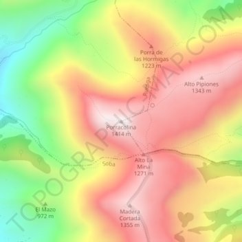
Name: Porracolina topographic map, elevation, terrain.
Location: Porracolina, Arredondo, Cantabria, 39728, España (43.23830 -3.66097 43.23840 -3.66087)
Average elevation: 1,056 m
Minimum elevation: 640 m
Maximum elevation: 1,382 m