Geolocate

Realp topographic map

Click on the map to display elevation.

About this map
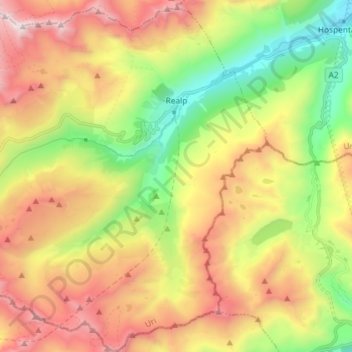
Name: Realp topographic map, elevation, terrain.

Location: Realp, Korporation Ursern, Uri, 6491, Switzerland (46.52761 8.40614 46.62727 8.53926)

Average elevation: 2,282 m

Minimum elevation: 1,450 m

Maximum elevation: 3,267 m

Other topographic maps

Click on a map to view its topography, its elevation and its terrain.
Rossbodenstock

Switzerland > Uri > Korporation Ursern > Andermatt

Average elevation: 2,392 m

Oberalppass

Switzerland > Uri > Korporation Ursern > Andermatt

Average elevation: 2,219 m

Gear up for your next adventure:

☕Camping Coffee Maker - Brew fresh coffee anywhere on the topographic map
🧳Compression Sacks - Maximize space in your backpack by shrinking gear
🧢Beanie Hat - Keep your head warm in cold weather
🧶550 Survival Paracord - Versatile utility cord for emergency repairs and rigging
🔪Outdoor Multitool - Versatile tool for repairs and food prep in the wild

As an Amazon Associate, this site earns from qualifying purchases at no extra cost to you.