
Make a donation
Gear up for your next adventure:
As an Amazon Associate, this site earns from qualifying purchases at no extra cost to you.
Mainville topographic map
Click on the map to display elevation.
Make a donation
Gear up for your next adventure:
As an Amazon Associate, this site earns from qualifying purchases at no extra cost to you.
About this map
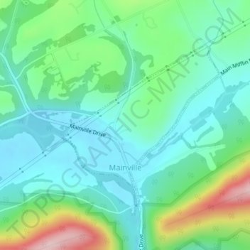
Name: Mainville topographic map, elevation, terrain.
Location: Mainville, Columbia County, Pennsylvania, United States (40.97172 -76.38374 40.98913 -76.36117)
Average elevation: 225 m
Minimum elevation: 157 m
Maximum elevation: 413 m
Make a donation
Gear up for your next adventure:
As an Amazon Associate, this site earns from qualifying purchases at no extra cost to you.
Other topographic maps
Click on a map to view its topography, its elevation and its terrain.
Mifflin Cross Roads
United States > Pennsylvania > Columbia County > Beaver Township
Average elevation: 312 m
Make a donation
Gear up for your next adventure:
As an Amazon Associate, this site earns from qualifying purchases at no extra cost to you.
Byrnesville
United States > Pennsylvania > Columbia County > Conyngham Township
Average elevation: 404 m
Hemlock Creek
United States > Pennsylvania > Columbia County > Buckhorn > Buckhorn
Average elevation: 207 m