
La Chareyre topographic map
Interactive map
Click on the map to display elevation.
About this map
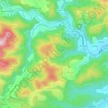
Name: La Chareyre topographic map, elevation, terrain.
Average elevation: 417 m
Minimum elevation: 272 m
Maximum elevation: 683 m
Other topographic maps
Click on a map to view its topography, its elevation and its terrain.
Les Soulhets
France > Auvergne-Rhône-Alpes > Ardèche > Fabras
Les Soulhets, Fabras, Largentière, Ardèche, Auvergne-Rhône-Alpes, France métropolitaine, 07380, France
Average elevation: 417 m
Ruisseau du Bruzet
France > Auvergne-Rhône-Alpes > Ardèche > Fabras > Les Soulhets
Ruisseau du Bruzet, Les Soulhets, Fabras, Largentière, Ardèche, Auvergne-Rhône-Alpes, France métropolitaine, 07380, France
Average elevation: 396 m