Geolocate

Savannah topographic map

Click on the map to display elevation.

About this map

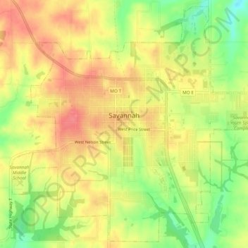
Name: Savannah topographic map, elevation, terrain.

Location: Savannah, Andrew County, Missouri, 64485, United States (39.92284 -94.85134 39.95730 -94.80404)

Average elevation: 329 m

Minimum elevation: 289 m

Maximum elevation: 356 m

Other topographic maps

Click on a map to view its topography, its elevation and its terrain.

Helena

United States > Missouri > Andrew County

Average elevation: 309 m

Gear up for your next adventure:

🧥Softshell Hiking Jacket - The perfect balance of wind protection and breathability
🚲Bike Repair Kit - Essential tools for on-trail mechanical issues
🥾Hiking Leggings - Comfortable leggings for outdoor activities
🔥Emergency Fire Starter - Reliable ignition source for all weather conditions
🧢Outdoor Cap - Protective cap for sun and rain during hikes

As an Amazon Associate, this site earns from qualifying purchases at no extra cost to you.