Geolocate

Bremo Bluff topographic map

Click on the map to display elevation.

About this map

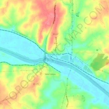
Name: Bremo Bluff topographic map, elevation, terrain.

Location: Bremo Bluff, Fluvanna County, Virginia, 23123, United States (37.69237 -78.31750 37.73237 -78.27750)

Average elevation: 95 m

Minimum elevation: 62 m

Maximum elevation: 136 m

Other topographic maps

Click on a map to view its topography, its elevation and its terrain.

Columbia

United States > Virginia > Fluvanna County

Average elevation: 78 m

Gear up for your next adventure:

👟Trail Running Shoes - Agile footwear for fast-paced topographic exploration
🥾Durable Hiking Shoes - Long-lasting shoes for frequent hiking
🦟Insect Repellent - Keep mosquitoes and black flies away in wooded areas
🔦LED Headtorch - Bright and durable light for night activities
🧥Waterproof Pants - Keep dry during rainy hiking conditions

As an Amazon Associate, this site earns from qualifying purchases at no extra cost to you.