Geolocate

Las Cunas topographic map

Click on the map to display elevation.

About this map

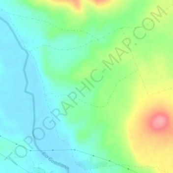
Name: Las Cunas topographic map, elevation, terrain.

Location: Las Cunas, Ciudad Real, Castile-La Mancha, Spain (38.98056 -4.02289 39.00056 -4.00289)

Average elevation: 606 m

Minimum elevation: 574 m

Maximum elevation: 677 m

Gear up for your next adventure:

🥾Trekking Poles - Adjustable trekking poles to reduce knee stress and improve stability
🎒Backpack Rain Cover - External shield to keep your entire pack dry
🧥Ultralight Puffy Jacket - Maximum warmth that packs down to the size of an orange
🔦LED Headtorch - Bright and durable light for night activities
🔭Compact Monocular - One-handed bird watching and trail spotting

As an Amazon Associate, this site earns from qualifying purchases at no extra cost to you.