
Make a donation
Gear up for your next adventure:
As an Amazon Associate, this site earns from qualifying purchases at no extra cost to you.
Demirkazık topographic map
Click on the map to display elevation.
Make a donation
Gear up for your next adventure:
As an Amazon Associate, this site earns from qualifying purchases at no extra cost to you.
Demirkazık
Demirkazık Peak (Turkish: Demirkazık Dağı) is a summit in Aladağlar a portion of Toros Mountains, Turkey. ("Demirkazık", literally "iron post" is the name of several summits in Turkey) Administratively, it is a part of Çamardı ilçe (district) of Niğde Province at 37°47′47″N 35°09′20″E / 37.79639°N 35.15556°E / 37.79639; 35.15556. Turkish Geography Atlas gives its altitude as 3,756 metres (12,323 ft). Being a conical mountain, it is a famous peak among mountaineers. However, it may not be the highest point of the mountain range.
Make a donation
Gear up for your next adventure:
As an Amazon Associate, this site earns from qualifying purchases at no extra cost to you.
About this map
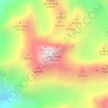
Name: Demirkazık topographic map, elevation, terrain.
Location: Demirkazık, Çamardı, Niğde, Central Anatolia Region, Turkey (37.83885 35.14805 37.83895 35.14815)
Average elevation: 3,049 m
Minimum elevation: 2,349 m
Maximum elevation: 3,722 m
Make a donation
Gear up for your next adventure:
As an Amazon Associate, this site earns from qualifying purchases at no extra cost to you.