
Make a donation
Gear up for your next adventure:
As an Amazon Associate, this site earns from qualifying purchases at no extra cost to you.
Yssingeaux topographic map
Click on the map to display elevation.
Make a donation
Gear up for your next adventure:
As an Amazon Associate, this site earns from qualifying purchases at no extra cost to you.
Yssingeaux
Yssingeaux (en occitan : Sinjaus) est une commune française située dans le département de la Haute-Loire, dont elle est une sous-préfecture depuis 1800, et dans la région Auvergne-Rhône-Alpes ; son altitude moyenne est d'environ 860 mètres.
Make a donation
Gear up for your next adventure:
As an Amazon Associate, this site earns from qualifying purchases at no extra cost to you.
About this map
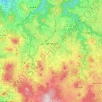
Name: Yssingeaux topographic map, elevation, terrain.
Average elevation: 903 m
Minimum elevation: 555 m
Maximum elevation: 1,358 m
Make a donation
Gear up for your next adventure:
As an Amazon Associate, this site earns from qualifying purchases at no extra cost to you.