Geolocate

Syokimau topographic map

Click on the map to display elevation.

About this map

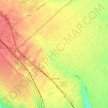
Name: Syokimau topographic map, elevation, terrain.

Location: Syokimau, Mavoko, Machakos County, 74416, Kenya (-1.39054 36.90919 -1.33876 36.96679)

Average elevation: 1,616 m

Minimum elevation: 1,575 m

Maximum elevation: 1,636 m

Other topographic maps

Click on a map to view its topography, its elevation and its terrain.

Kinanie ward

Kenya > Machakos County > Mavoko

Average elevation: 1,616 m

Kinanie ward

Kenya > Machakos County > Mavoko

Average elevation: 1,616 m

Gear up for your next adventure:

🥾Approach Boots - Comfortable boots for hiking and climbing approaches
🏕️Camping Hammock - Integrated protection for sleeping between trees
Lightweight Camping Tent - Portable shelter optimized for Canadian backcountry camping
🥾Waterproof Hiking Boots - Boots keeping your feet dry in wet conditions
🧥Thermal Fleece Jacket - Versatile insulation for changing mountain temperatures

As an Amazon Associate, this site earns from qualifying purchases at no extra cost to you.