Geolocate

Pakrac topographic map

Click on the map to display elevation.

About this map

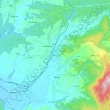
Name: Pakrac topographic map, elevation, terrain.

Location: Pakrac, Grad Pakrac, Požega-Slavonia County, 34550, Croatia (45.39623 17.15293 45.47623 17.23293)

Average elevation: 227 m

Minimum elevation: 138 m

Maximum elevation: 653 m

Gear up for your next adventure:

🧰Survival Kit - Essential gear for emergencies in the wilderness
🔪Outdoor Multitool - Versatile tool for repairs and food prep in the wild
🔦LED Headtorch - Bright and durable light for night activities
🧥Packable Rain Jacket - Breathable waterproof layer for unpredictable weather
🥾Mountain Trail Shoes - High-traction shoes for mountain trails

As an Amazon Associate, this site earns from qualifying purchases at no extra cost to you.