
Make a donation
Gear up for your next adventure:
As an Amazon Associate, this site earns from qualifying purchases at no extra cost to you.
Llorac topographic map
Click on the map to display elevation.
Make a donation
Gear up for your next adventure:
As an Amazon Associate, this site earns from qualifying purchases at no extra cost to you.
About this map
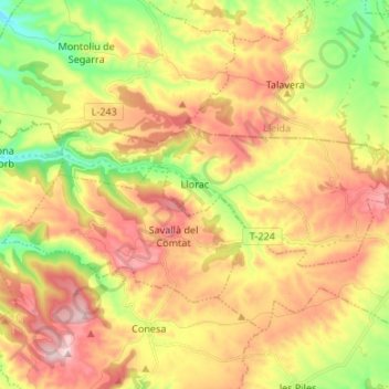
Name: Llorac topographic map, elevation, terrain.
Location: Llorac, Cuenca de Barberá, Tarragona, Cataluña, 43427, España (41.53495 1.25914 41.57216 1.39298)
Average elevation: 725 m
Minimum elevation: 554 m
Maximum elevation: 893 m
Make a donation
Gear up for your next adventure:
As an Amazon Associate, this site earns from qualifying purchases at no extra cost to you.
Other topographic maps
Click on a map to view its topography, its elevation and its terrain.
el Balneari de Vallfogona
España > Cataluña > Cuenca de Barberá > Vallfogona de Riucorb
Average elevation: 694 m
Make a donation
Gear up for your next adventure:
As an Amazon Associate, this site earns from qualifying purchases at no extra cost to you.
Rocafort de Queralt
España > Cataluña > Cuenca de Barberá > Rocafort de Queralt > Rocafort de Queralt
Average elevation: 603 m
Vilanova de Prades
España > Cataluña > Cuenca de Barberá > Vilanova de Prades > Vilanova de Prades
Average elevation: 845 m
Make a donation
Gear up for your next adventure:
As an Amazon Associate, this site earns from qualifying purchases at no extra cost to you.
Belltall
España > Cataluña > Cuenca de Barberá > Passanant i Belltall > Belltall
Average elevation: 735 m