Geolocate

Centerville topographic map

Click on the map to display elevation.

About this map

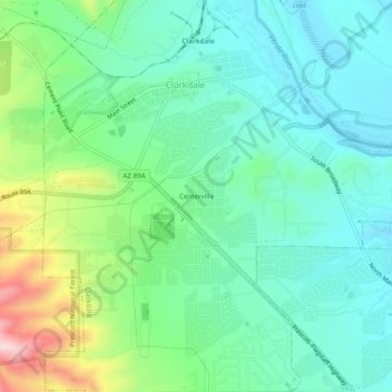
Name: Centerville topographic map, elevation, terrain.

Location: Centerville, Clarkdale, Yavapai County, Arizona, 86324, United States (34.73974 -112.07655 34.77974 -112.03655)

Average elevation: 1,103 m

Minimum elevation: 1,012 m

Maximum elevation: 1,353 m

Other topographic maps

Click on a map to view its topography, its elevation and its terrain.

Gear up for your next adventure:

📷Outdoor Action Camera - Capture high-elevation views and rugged adventures
💡Portable Camping Lamp - Rechargeable lamp for campsite lighting
🧦Hiking Socks - Moisture-wicking and comfortable socks for long hikes
🛁Quick-Dry Microfiber Towel - Space-saving towel that dries rapidly on the move
🎒Fully Waterproof Backpack - Total protection for photography gear and electronics

As an Amazon Associate, this site earns from qualifying purchases at no extra cost to you.