
Make a donation
Gear up for your next adventure:
As an Amazon Associate, this site earns from qualifying purchases at no extra cost to you.
Mühlbachl topographic map
Click on the map to display elevation.
Make a donation
Gear up for your next adventure:
As an Amazon Associate, this site earns from qualifying purchases at no extra cost to you.
About this map
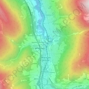
Name: Mühlbachl topographic map, elevation, terrain.
Average elevation: 1,274 m
Minimum elevation: 878 m
Maximum elevation: 1,840 m
Make a donation
Gear up for your next adventure:
As an Amazon Associate, this site earns from qualifying purchases at no extra cost to you.
Other topographic maps
Click on a map to view its topography, its elevation and its terrain.
Wipptal
Österreich > Tirol > Bezirk Innsbruck-Land > Matrei am Brenner
Das Wipptal ist wegen der geringen Höhe des Brennerpasses seit langem eine der bedeutendsten Nord-Süd-Verkehrsachsen durch die Alpen. Bereits in der Römerzeit verband die Via Raetia, an der die Straßenstationen Matreium und Vipitenum lagen, die Provinz Rätien mit Norditalien. Heute verlaufen hier die…
Average elevation: 1,699 m