Geolocate

Botad topographic map

Click on the map to display elevation.

About this map

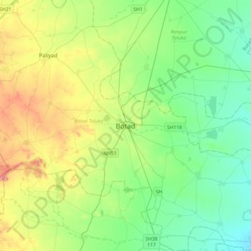
Name: Botad topographic map, elevation, terrain.

Location: Botad, Botad Taluka, Botad, Gujarat, 364700, India (22.00860 71.50850 22.32860 71.82850)

Average elevation: 85 m

Minimum elevation: 27 m

Maximum elevation: 226 m

Gear up for your next adventure:

🥾Approach Boots - Comfortable boots for hiking and climbing approaches
🛌Down Sleeping Bag - Superior warmth-to-weight ratio for cold nights
👖Convertible Hiking Pants - Zip-off legs to adapt to changing weather conditions
Backpacking Tent - Lightweight tent for long-distance hiking trips
🧢Sun Protection Cap - Breathable cap to protect from sun exposure

As an Amazon Associate, this site earns from qualifying purchases at no extra cost to you.