
Make a donation
Gear up for your next adventure:
As an Amazon Associate, this site earns from qualifying purchases at no extra cost to you.
Linow topographic map
Click on the map to display elevation.
Make a donation
Gear up for your next adventure:
As an Amazon Associate, this site earns from qualifying purchases at no extra cost to you.
About this map
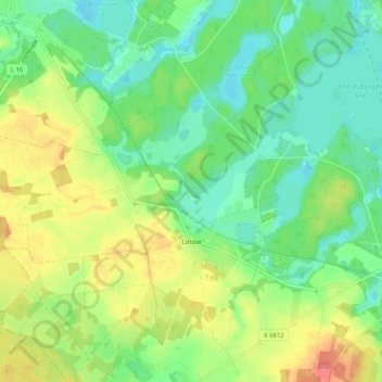
Name: Linow topographic map, elevation, terrain.
Average elevation: 74 m
Minimum elevation: 48 m
Maximum elevation: 117 m
Make a donation
Gear up for your next adventure:
As an Amazon Associate, this site earns from qualifying purchases at no extra cost to you.
Other topographic maps
Click on a map to view its topography, its elevation and its terrain.
Kleiner Stechlinsee
Deutschland > Brandenburg > Ostprignitz-Ruppin > Rheinsberg > Stechlin
Average elevation: 71 m
Kleiner Wummsee
Deutschland > Brandenburg > Ostprignitz-Ruppin > Rheinsberg > Flecken Zechlin
Average elevation: 82 m
Großer Zechliner See
Deutschland > Brandenburg > Ostprignitz-Ruppin > Rheinsberg > Flecken Zechlin
Average elevation: 67 m
Großer Prebelowsee
Deutschland > Brandenburg > Ostprignitz-Ruppin > Rheinsberg > Zechlinerhütte
Average elevation: 65 m
Make a donation
Gear up for your next adventure:
As an Amazon Associate, this site earns from qualifying purchases at no extra cost to you.
Kleiner Prebelowsee
Deutschland > Brandenburg > Ostprignitz-Ruppin > Rheinsberg > Zechlinerhütte
Average elevation: 65 m
Dorfstraße
Deutschland > Brandenburg > Ostprignitz-Ruppin > Rheinsberg > Flecken Zechlin
Average elevation: 89 m
Make a donation
Gear up for your next adventure:
As an Amazon Associate, this site earns from qualifying purchases at no extra cost to you.