Geolocate

Noguera topographic map

Click on the map to display elevation.

About this map

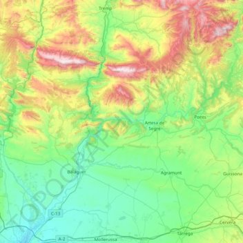
Name: Noguera topographic map, elevation, terrain.

Location: Noguera, Lleida, Catalonia, Spain (41.68572 0.56188 42.12293 1.31381)

Average elevation: 547 m

Minimum elevation: 152 m

Maximum elevation: 1,661 m

Other topographic maps

Click on a map to view its topography, its elevation and its terrain.

Gear up for your next adventure:

🧶550 Survival Paracord - Versatile utility cord for emergency repairs and rigging
💧Hydration Pack - Hands-free hydration system for long hikes
🥾Light Hiking Boots - Lightweight and comfortable boots for day hikes
💡Compact LED Flashlight - Powerful and portable flashlight for outdoor use
🧴Waterproofing Spray - Restore the DWR coating on jackets and tents

As an Amazon Associate, this site earns from qualifying purchases at no extra cost to you.