
Make a donation
Gear up for your next adventure:
As an Amazon Associate, this site earns from qualifying purchases at no extra cost to you.
L'Houmeau topographic map
Click on the map to display elevation.
Make a donation
Gear up for your next adventure:
As an Amazon Associate, this site earns from qualifying purchases at no extra cost to you.
About this map
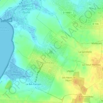
Name: L'Houmeau topographic map, elevation, terrain.
Average elevation: 12 m
Minimum elevation: -5 m
Maximum elevation: 29 m
Make a donation
Gear up for your next adventure:
As an Amazon Associate, this site earns from qualifying purchases at no extra cost to you.
Other topographic maps
Click on a map to view its topography, its elevation and its terrain.
Make a donation
Gear up for your next adventure:
As an Amazon Associate, this site earns from qualifying purchases at no extra cost to you.
Barabe
France > Nouvelle-Aquitaine > Charente-Maritime > Chenac-Saint-Seurin-d'Uzet
Average elevation: 12 m
Saint-Seurin-d'Uzet
France > Nouvelle-Aquitaine > Charente-Maritime > Chenac-Saint-Seurin-d'Uzet
Average elevation: 14 m
Make a donation
Gear up for your next adventure:
As an Amazon Associate, this site earns from qualifying purchases at no extra cost to you.
Mauzac
France > Nouvelle-Aquitaine > Charente-Maritime > Saint-Just-Luzac > Luzac
Average elevation: 4 m
Make a donation
Gear up for your next adventure:
As an Amazon Associate, this site earns from qualifying purchases at no extra cost to you.
Chassiron
France > Nouvelle-Aquitaine > Charente-Maritime > Saint-Denis-d'Oléron
Average elevation: 2 m
Les Bris
France > Nouvelle-Aquitaine > Charente-Maritime > Saint-Trojan-les-Bains
Average elevation: 4 m
Make a donation
Gear up for your next adventure:
As an Amazon Associate, this site earns from qualifying purchases at no extra cost to you.
Saint-Denis-d'Oléron
France > Nouvelle-Aquitaine > Charente-Maritime > Saint-Denis-d'Oléron > Saint-Denis-d'Oléron
Average elevation: 3 m
Forêt du Douhet
France > Nouvelle-Aquitaine > Charente-Maritime > La Brée-les-Bains > Forêt du Douhet
Average elevation: 1 m