Geolocate

Bela topographic map

Click on the map to display elevation.

About this map

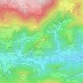
Name: Bela topographic map, elevation, terrain.

Location: Bela, Kamnik, Upravna Enota Kamnik, 1221, Slovenia (46.20334 14.84010 46.24334 14.88010)

Average elevation: 760 m

Minimum elevation: 429 m

Maximum elevation: 1,343 m

Gear up for your next adventure:

🔭Compact Monocular - One-handed bird watching and trail spotting
🧢Outdoor Visor - Breathable visor for sunny hikes
🧰Emergency Multi-Tool - Compact multi-tool for outdoor survival
🚲Bike Repair Kit - Essential tools for on-trail mechanical issues
🥾Hiking Shoes - Durable and comfortable shoes for trail hiking

As an Amazon Associate, this site earns from qualifying purchases at no extra cost to you.