
Make a donation
Gear up for your next adventure:
As an Amazon Associate, this site earns from qualifying purchases at no extra cost to you.
Vilopriu topographic map
Click on the map to display elevation.
Make a donation
Gear up for your next adventure:
As an Amazon Associate, this site earns from qualifying purchases at no extra cost to you.
About this map
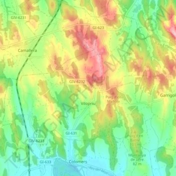
Name: Vilopriu topographic map, elevation, terrain.
Location: Vilopriu, Bas-Ampurdan, Gérone, Catalogne, 17144, Espagne (42.07916 2.95193 42.14007 3.02088)
Average elevation: 79 m
Minimum elevation: 18 m
Maximum elevation: 166 m
Make a donation
Gear up for your next adventure:
As an Amazon Associate, this site earns from qualifying purchases at no extra cost to you.
Other topographic maps
Click on a map to view its topography, its elevation and its terrain.
Platja d'Aro
Espagne > Catalogne > Bas-Ampurdan > Castell d'Aro, Platja d'Aro i s'Agaró
Average elevation: 47 m
Castell d'Aro
Espagne > Catalogne > Bas-Ampurdan > Castell d'Aro, Platja d'Aro i s'Agaró
Average elevation: 94 m
Make a donation
Gear up for your next adventure:
As an Amazon Associate, this site earns from qualifying purchases at no extra cost to you.
Make a donation
Gear up for your next adventure:
As an Amazon Associate, this site earns from qualifying purchases at no extra cost to you.