Geolocate

Reus topographic map

Click on the map to display elevation.

About this map

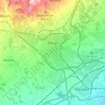
Name: Reus topographic map, elevation, terrain.

Location: Reus, Baix Camp, Tarragona, Catalonia, 43201, Spain (41.10238 1.05753 41.19021 1.19135)

Average elevation: 119 m

Minimum elevation: 8 m

Maximum elevation: 411 m

Gear up for your next adventure:

Camping Groundsheet - Protect your tent from moisture and dirt
Family Camping Tent - Spacious tent suitable for family camping trips
🧴Waterproofing Spray - Restore the DWR coating on jackets and tents
🛁Quick-Dry Microfiber Towel - Space-saving towel that dries rapidly on the move
🥾Waterproof Hiking Boots - Boots keeping your feet dry in wet conditions

As an Amazon Associate, this site earns from qualifying purchases at no extra cost to you.