
Make a donation
Gear up for your next adventure:
As an Amazon Associate, this site earns from qualifying purchases at no extra cost to you.
Norman topographic map
Click on the map to display elevation.
Make a donation
Gear up for your next adventure:
As an Amazon Associate, this site earns from qualifying purchases at no extra cost to you.
About this map
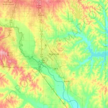
Name: Norman topographic map, elevation, terrain.
Location: Norman, Cleveland County, Oklahoma, 73069, United States (35.06257 -97.59948 35.38257 -97.27948)
Average elevation: 356 m
Minimum elevation: 317 m
Maximum elevation: 416 m
Make a donation
Gear up for your next adventure:
As an Amazon Associate, this site earns from qualifying purchases at no extra cost to you.
Other topographic maps
Click on a map to view its topography, its elevation and its terrain.
Lake Thunderbird
United States > Oklahoma > Cleveland County > Norman > Little Axe
Average elevation: 334 m
Sutton Urban Wilderness Park
United States > Oklahoma > Cleveland County > Norman
Average elevation: 365 m