
Make a donation
Gear up for your next adventure:
As an Amazon Associate, this site earns from qualifying purchases at no extra cost to you.
Lenders topographic map
Click on the map to display elevation.
Make a donation
Gear up for your next adventure:
As an Amazon Associate, this site earns from qualifying purchases at no extra cost to you.
Lenders
Lenders befindet sich etwa einen Kilometer Luftlinie südlich des Hauptortes am südlichen Rand des Oechsetales. Über Lenders führt ein schmaler Fahrweg (heute Abschnitt des Thüringer Jakobsweges) in das südlich angrenzende Kohlbachtal nach Gerstengrund, Zitters und Kranlucken. Die geographische Höhe des Ortes beträgt 555 m ü. NN.
Make a donation
Gear up for your next adventure:
As an Amazon Associate, this site earns from qualifying purchases at no extra cost to you.
About this map
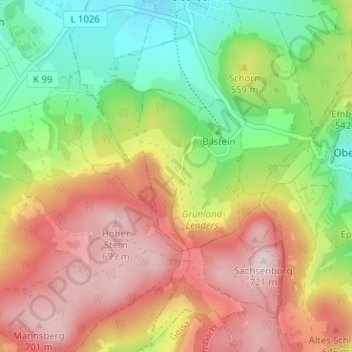
Name: Lenders topographic map, elevation, terrain.
Average elevation: 549 m
Minimum elevation: 391 m
Maximum elevation: 714 m
Make a donation
Gear up for your next adventure:
As an Amazon Associate, this site earns from qualifying purchases at no extra cost to you.