
Thank you for supporting this site ❤️
Make a donation
Make a donation
Gear up for your next adventure:
As an Amazon Associate, this site earns from qualifying purchases at no extra cost to you.
Söcking topographic map
Click on the map to display elevation.
Thank you for supporting this site ❤️
Make a donation
Make a donation
Gear up for your next adventure:
As an Amazon Associate, this site earns from qualifying purchases at no extra cost to you.
Söcking
Söcking liegt auf einer Höhe von 695 m ü. NN auf den Endmoränen der Würmeiszeit am Starnberger See. Der Stadtteil befindet sich oberhalb und nordwestlich von Starnberg, an einer Hanglage zwischen Maisinger Schlucht und Alersberg.
Thank you for supporting this site ❤️
Make a donation
Make a donation
Gear up for your next adventure:
As an Amazon Associate, this site earns from qualifying purchases at no extra cost to you.
About this map
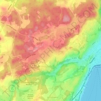
Name: Söcking topographic map, elevation, terrain.
Average elevation: 651 m
Minimum elevation: 583 m
Maximum elevation: 698 m
Thank you for supporting this site ❤️
Make a donation
Make a donation
Gear up for your next adventure:
As an Amazon Associate, this site earns from qualifying purchases at no extra cost to you.