
Make a donation
Gear up for your next adventure:
As an Amazon Associate, this site earns from qualifying purchases at no extra cost to you.
Farah topographic map
Click on the map to display elevation.
Make a donation
Gear up for your next adventure:
As an Amazon Associate, this site earns from qualifying purchases at no extra cost to you.
Farah
Sitting at an elevation of approximately 650 m (2,130 ft) above sea level, Farah is one of the largest cities in western Afghanistan. It is located on the Farah River, roughly 125 km (78 mi) from the Afghanistan–Iran border. The city has a land area of 29 km2 (11 sq mi) or 2,949 ha (7,290 acres). In 2025 there were 5,299 dwelling units in it.
Make a donation
Gear up for your next adventure:
As an Amazon Associate, this site earns from qualifying purchases at no extra cost to you.
About this map
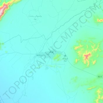
Name: Farah topographic map, elevation, terrain.
Location: Farah, Farah Province, Afghanistan (32.21409 61.95463 32.53409 62.27463)
Average elevation: 697 m
Minimum elevation: 615 m
Maximum elevation: 1,782 m
Make a donation
Gear up for your next adventure:
As an Amazon Associate, this site earns from qualifying purchases at no extra cost to you.